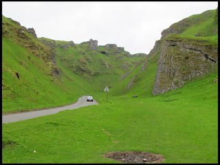
What a difference in the weather! It was cloudy with sunny spells
and very humid and a lot warmer. I had planned on a traverse of part
of the Great Ridge which separates the Hope and Edale valleys.
After parking up in the layby close to the cave known as Windy
Knoll below Mam Tor, I got my boots on and wearing only a thermal
shirt, set off on the path which leads from the gate on the layby
heading towards Winnats Farm at the top of Winnats Pass.
As I crossed the fields behind the farm buildings, I found a ewe
and her two lambs with the ewe laying with her feet point upslope and
she was bleating. It was obvious she had got herself “cast” where
because of the slope and the position she was lying, she was unable
to get to her feet.
I grabbed one of her hind legs and pulled her around so that her
back was now upslope and she started bucking her legs to try and
stand up. Sometimes a ewe will get “cast” and then exhaust
herself thrashing around trying to regain her feet, but this ewe was
obviously not at all tired, mush less exhausted, and as I gave here a
helpful shove on her back, she was soon back on her feet.
She walked a few metres away and returned to the business of
grazing while here lambs joined in.
I followed the path through the Blue John Cavern car park and out
the other side to a narrow path contouring the slope above Odin Mine
and Cave to arrive at Treak Cliff Cavern, which is another show cave
like Blue John Cavern, where the rare Blue John stone was once mined.
After dropping down the concrete path belonging to Treak Cliff
Cavern to reach the Castleton Road, I followed the roadside path for
a few hundred metres until I was at a stile leading to a short path
across grass to Speedwell Cavern, at the foot of Winnats Pass.
Next was the public footpath leading alongside a field wall below
a large sweep of sloping pasture which brings you to a field gate and
then onto a road in Castleton village near the Peak Cavern (or as
they prefer to be know nowadays by the older name of The Devil's
Arse!).
The road leads to the village centre at the old Market Square
where the Castleton Youth Hostel was until it was sold and a new one
opened at Losehill Hall further up the road towards Hope.
I succumbed to temptation and had an ice cream which I ate while
perched on one of the stone sections surrounding the village war
memorial, after which I stopped at one of the village shops to buy a
sausage roll for lunch.
I followed the road leading out of the village centre towards the
Hollowford Outdoor Centre and then along a vehicle track passing
behind the new Youth Hostel at Losehill Hall until I was at a public
footpath leading upwards across fields. The signpost was rotten but
you could just make out “ose Hil” of Lose Hill, where the path
was leading to.
After a gradually-rising path passing more ewes and lambs, I
joined a path leading up to Lose Hill we had followed some time ago,
from Hope train station. There was a group of you girl back-packers,
presumably on a “Duke of Edinburgh” week-end, also heading
towards the top of Lose Hill.
Soon I was walking up the rough rocky steps near the top of Lose
Hill and then passing the busy summit, I found a small grassy hollow
out of the wind overlooking the Edale valley, where I stopped for a
quick snack.
Continuing along the Great Ridge, I crossed Back Tor and Hollins
Cross and then beneath the paragliders as I walked up towards the
highest point: the summit of Mam Tor. As this summit is only a short
and easy walk from a car park it is usually very busy, especially
when the weather is good, as it was today.
I dropped down from the summit of Mam Tor to the road at Mam Nick
and then down the sloping field back to my starting point.


No comments:
Post a Comment