Sunday, 6 January 2013

Shining Tor from Erwood Reservoir

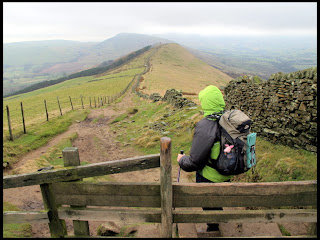
After leaving the car in the southern car park by Errwood Reservoir in the Goyt Valley, we made our way up the grassy path along side Shooters Clough. Although it was a cool day (about 6C), I was wearing only a thermal shirt as I didn't wan to get too warm on the ascent.
When we left home, Winster was enveloped in mist and fog and there were clear patches as we travelled towards Buxton on the A525. As we were approaching Buxton earlier on the A515 we could see clouds of mist in the distance filling valleys with the hilltops standing clear which looked very picturesque: a classic temperature inversion.
We were hoping for lovely views from Shining Tor, a hill overlooking the Goyt Valley some 4 miles from Buxton but it was not to be, In fact it was the opposite case with the lower ground completely clear and the higher ground shrouded in mist.
As we followed what was obviously an ancient track as it had been worn down through soft ground until it reached bedrock, we reached a high point where the track continued towards the Cat and Fiddle inn and another path formed a junction. This path leads to the top of Shining Tor.
We stopped for a minute so that I could put on my Rab Vapour Rise jacket (which was ideal for a day like today which was cool, damp and with a cold wind) and then followed the improved path across the boggy moorland to arrive at the high point of Shining Tor at 559 metres.
There are a pair of wooden benches at the top in a corner of two drystone walls which are somewhat sheltered from the prevailing wind, but the one which was best sheltered was already in use by a lady and a young girls, so we went though a small gate in the wall by the old trig. point and sat in the shelter of one of the small gritstone craglets which overlook the slopes on the other side of Shining Tor and had our lunch.
Continuing onwards in the mist, we followed the path, which like many others in the Peak moorland, has been improved with large stone slabs, northwards towards Cats Tor. As we went along we could hear the odd grouse making its odd call of “Ack! Ack ack ack! Go back! Go back! Go back!”.
We eventually arrived at Pym Chair which is next to a minor road and here we had another short break in the shelter provided by the drystone-wall and a hollowing on the ground before we made our way gradually down a footpath alongside the road until it got too churned and muddy by trial bikes and then just walk on the road instead.
At a footpath sign and finger post by the road, we left the road to follow a well-used path which leads down through the woodland near the old Erwood Hall ruins, and stopped to have a quick look at the “Spanish Shrine”.
The “Spanish Shrine” is a tiny shrine or chapel built by the old proprietors of Erwood Hall, the Grimshaws in the 19th century in memory of their Spanish governess who had died on a trip to Lourdes.
We followed the path onwards down through the woodland which brought us back to the road next to Erwood Reservoir near our starting point.

The track leading up by Shooters Clough

Tiny lichen on some rock

Inside the Spanish Shrine

Inside the Spanish Shrine

The Spanish Shrine


Saturday, 5 January 2013

Lose Hill from Castleton

After parking in the centre of Castleton, we followed Hollowford Road as far as the Hollowford Outdoor Centre and then along a track which is a Public Right of Way which passed behind Losehill Hall which recently became the location of Castleton Youth Hostel which used to be in a smaller building on the Market Square.
The track continued as far as Spring House Farm from where a concreted farm track followed uphill towards the top of Lose Hill.
The Right of Way on the track left the track at a stile into a very muddy corner of a field and then continued uphill to meet another footpath near Losehill Farm which we then followed to a piece of land called Wards Piece after crossing two more stiles.
A section of path with rocky steps then brought us to the summit of Lose Hill where we found a spot sheltered from the cold wind on the Edale side of the hill just below the summit. We sat here for a short break and a coffee from our flasks.
We then followed the path along the Great Ridge heading towards Mam Tor. Luckily it was clear, if a bit hazy unlike Kinder Scout and Bleaklow which largely were covered with cloud.
We dropped down Back Tor and arrived at Hollins Cross. Again, we dropped downhill s short distance to find shelter from the wind and ate our lunch.
From Hollins Cross we dropped down from the ridge on a gradually dropping path leading to Mam Farm after the path joined a farm track for a short distance. The path was very muddy in parts and a bit slippery.
There was a small gate by the farm which led to another Public Footpath which we could see on the map headed back towards Castleton. We started following a path formed by shortened grass heading towards a farm in the distance. Soon we realised we had gone wrong as we appeared to be on a sheep track and arrived at a fence, although one corner was collapsed on the ground. After studying the map for moment, we realised we had veered off the route of the path which should be more over towards the old road from Mam Tor near to Odins Mine.
So we retraced our route for a short distance and soon found a small gate and well used and muddy path which confirmed we were back on our intended path.
Near to here we were passing what looked like an old gritstone gate post which I noticed had an odd pattern of lines on its face. After having a closer look I saw it was a shallow carving of a hand holding a small hammer. On the opposite face, there was another shallow carving with a hand with an extended index finger pointing upwards and the words “Odin Mine” above it. So obviously this was and old Guide Stoop  indicating the route to nearby Odin Mine. The Public Right of Way we were following was probably the old route miners would have taken from the village of Castleton to and from the mine in years gone by.
We followed the path across several fields along side a small brook called Odin Sitch. Soon we walked between two high stone garden walls passing between a couple of houses opposite Peak Cavern or “The Devils Arse” and we joined the footpath alongside the road from Winnats Pass into Castleton village.

Summit of Lose Hill, Mam Tor in the distance

Back Tor

A section of the Great Ridge

Dropping Down from Hollins Cross

Guide Stoop (carving of hand holding hammer)

Other side of Guide Stoop (finger pointing way to Odin Mine)

Close up of Guide Stoop

Castleton


Tuesday, 1 January 2013

Kinder Scout

To begin the New Year, Karen and I had a walk on Kinder Scout.
It was a much colder day than yesterday and windier too as we left the car park in Edale and set off to the village centre.
We followed the start of the Pennine Way before turning off to gain the plateau via Grindslow Knoll. At the top of the Knoll we sat in a relatively sheltered spot to have a hot drink then braving the hail and wins and mist, we continued to follow the edge path heading eastwards so that the strong wind would be at our backs.
Again we had a short break in the shelter of small gritstone tors part of the way towards Ringing Roger, where we made the start of our descent back to Edale.
We found the wind very strong as we walked along the top of Ringing Roger and made for a very sheltered and flat spot on the east side where we again had a short break and also found the waterproof plastic box containing various items which appeared to be a Geocache.
We made our way down the eastern side of Ringing Roger to reach the path which zigzags down towards Grindsbrook Booth.
We were looking forward to a teas and a snack in the café but the café at Coopers Farm campsite was closed (it being New Year's Day) but fortunately the National Trust café by Edale train station, “The Penny Pot” was open and we had our snack and mug of tea there.


Monday, 31 December 2012

Three Shire Heads from Wildboarclough

After leaving the car at a small abandoned quarry by the road in the Cheshire village of Wildboarclough, we walked northwards about a kilometre along the minor road and then left it to follow a track passing the small Cumberland Cottage. As it had been forecast, it was windy and wet.
At a bend in the track, we continued again to the north, on a path which followed a small valley with a small brook. There was a small ruined building which offered some shelter from the cold wind and as the rain had stopped for a while, we sat there to have a hot drink and some food.
The path continued for a short distance to arrive at a T-junction with a bridleway heading to the south-east and north-west towards the Cat and Fiddle inn. Following the rocky-surfaced bridleway brought us to the A54 road.
We crossed the road to the other side and followed a rougher track which brought us through the remains of the Danebower quarries and then after about half a kilometre we passed through a metal field gate with a smaller gate built inside it, to follow a footpath across boggy moorland to the south and then after a bend joined another rough track which leads down to Panniers Pool at Three Shire Heads.
We had another short stop at the picturesque pool and waterfalls and had another hot drink as someone on a trial bike road by despite there being no access allowed for motorised vehicles.
Continuing on again, we crossed the small pack-horse bridge and followed the stony track as it gradually rose and curved towards a minor road below Cut-thorn Hill where the route continued on the other side after passing a stile.
A vague path continued across fields to again arrive at the A54 again which we then recrossed to continue on a continuing path the other side which had short sections of raised wooden walkways due to the very boggy going.
After passing a small stone barn, we joined a minor road after walking a short distance through a small wood near the large Crag Hall in Wildboarclough.
After yet another short distance walking down the minor road, we again reached our starting point.


Sunday, 30 December 2012

Robins Shaft Mine

After yesterday's lounging around at home due to the non-stop rain, Karen Keith and myself were glad to have a much drier day today. We had met Keith as arranged yesterday morning in Monyash for breakfast at the café but it was pissing down and the café was closed until next weekend. So we quickly decided to “sod this” and stay indoors for a change as the forecast was for a very wet day, and it proved to be accurate!
We collected a 100 metre rope from the Orpheus CC cottage and then drove south through Alstonefield just over the border in Staffordshire for a quick trip in Robins Shaft Mine.
We parked in the farmyard and asked permission to enter the mine and paid our £1.50 each fee. The farmer allowed us to change in the adjacent barn as it was a very cold and strong wind blowing today and we were grateful of the shelter.
Keith began rigging sown the 100 metre shaft as Karen and I were sheltering from the wind by the drystone wall partly surrounding the entrance.
Soon Karen followed and I brought up the rear.
This is a very peculiar mine with the shaft at an angle varying from 45 to 60 degrees with several convenient ledges cut horizontally into it which provide very easy rebelays.
Our rope didn't quite reach the bottom of the shaft but luckily did reach the natural cave section some 10 metres from the bottom which was where we intended to have a look at anyway as the foot of the shaft doesn't really bring you to any significant length of passage.
We had a good poke around the natural cave section with a lovely small domed ceiling in one section and also some boulders which were very yellow in colour with sections of red colouration. Very interesting geology.
Soon we started back to the surface in the reverse order with me first followed by Karen and then Keith de-rigging as he went. It is surprisingly easy re-ascending the 100 meters on an inclined shaft as compared to a vertical one.
We changed out of caving gear in the barn and then said “good-bye” to Keith who was heading home to Rugby for the New Year.

Thursday, 27 December 2012

Eyam Moor

Originally we planned on a walk from Hope along part of the Great Ridge via Lose Hill but when we parked in Hope I found that I had left my walking socks at home. Rats.
So we dropped in at Outside in Hathersage so that I could but a pair (which wasn't a waste as some pairs of socks I have are getting towards the end of their life).
Since we had now wasted some time and were heading away from home of we returned to Hope, we changed our plans to walk in the Eyam Moor area from Sir William Hill.
So, after parking up on the rough track across Sir William Hill and putting on my new socks and walking boots (which have a broken lace loop but I picked up the wrong boots as well as forgetting my socks – D'oh!), we walked the kilometre plus of track arriving at a junction with tarmaced road.
From here we followed another track with a soft, muddy surface as it dropped down to Nether Bretton and a minor road.
After following this road south-westwards for one or two hundred metres, we then followed a public footpath which began on a drive belonging to a house next to the road and then along the side of the house to a stile brining us to some large fields.
The path continued across the fields and then steeply down some muddy steps to soon arrive at a small footbridge crossing the Bretton Brook.
On the other side of the brook, the path continued upwards along a valley and then after another stile, some more fields passing Cockey Farm to eventually arrive at the small village or hamlet of Abney.
From here, we followed a muddy path leading down Abney Clough to Stoke Ford and then after crossing another footbridge, the route gradually rose to eventually bring us to the top of the side of Bretton Clough and we stopped for a short break in the shelter of a very small crag to get out of the cold wind.
From here we made our way along the path to reach the drystone-wall forming the boundary of Eyam Moor where we crossed the wall using a stile and then crossed the heathery and in parts wet moorland.
Soon we were back at the wall running along side Sir William Hill Road where we started our walk.


Sunday, 23 December 2012

Grindleford to Longshaw Estate

A shorter walk today with dry and sunny weather forecast as we parked in the road leading to Grindleford café.
We climbed the steps from the car park and crossed a road then again climbed more steps rising through woods until we reached the top and the path levelled out.
This brought us to a wall and a gate opening on to the Longshaw Estate and after crossing a lovely open wooded area, we headed for the beautiful old Lodge which is now owned by the National Trust and had cake and tea in the café.
Afterwards we followed a path through the Estate arriving at the same road as before, from the opposite side and further along towards Higgar Tor and after crossing the road and again passing through a wall with a gate, we were at the top of Padley Gorge.
We followed the path as it gradually descended the wooded gorge parallel to the stream
Soon we were back at the road passing Totley Tunnel and we had more tea and a snack in Grindleford Cafe, one of the best in the Peak!