Friday 23 September 2011

Kinlochleven to Fort William, The Finish – 15 Miles

After breakfast at 08:00, we left the Bed and Breakfast at 09:05 in the unsurprising rain to follow the West Highland Way out of Kinlochleven.
Soon the path left the town via a gradually-rising and zigzagging path bringing us to a track which runs along one side of 
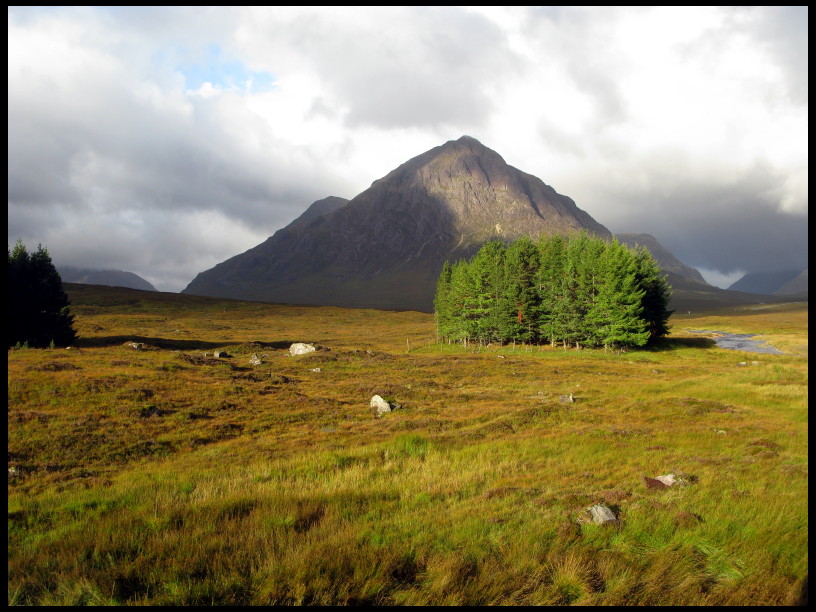
the broad valley containing Loch Leven.
The track passed the ruins of Tigh-na-Sleubhaich after a couple of hours so we sat in the shelter of one of the walls of an adjacent sheep pen to to have a hot drink and snack.
Luckily the rain had mostly stopped but the clouds were still covering the hill tops. This section of the walk was more crowded than other days and we were passed by several familiar and unfamiliar walkers, and we could see more walkers in the distance as there was a good view of the path for several kilometres ahead.
The track, and old military road, was the usual story of rough and undulating gradually as it followed one side of the wide valley.
After a few kilometres, the valley and the track turned North and soon entered a wooded area.
In a clearing, we sat on a couple of tree stumps and ate some of our packed lunch then, as a few midges made their presence known, we set off again.
After a cleared are we entred a wood again and then another cleared area then back into wood again. All the time drizzle or light was starting or stopping.
The path then joined a forestry track which gradually dropped us down towards Glen Nevis which we could see below in the distance. Unfortuntely, there was not much of Ben Nevis to see because of the cloud.
Tramping along the hard surface of the forestry track soon had our feet complaining. Up to now it had been a very enjoyable walk with lovely scenery despite the weather.
Following a sign, we quit the forestry track and followed a footpath for a few hundred metres to join the minor road in Glen Nevis.
This road seemed interminable as our sore feet got sorer as we followed the pavement or the road into Fort William after a couple of kilomteres or so.
We paused at a small bridge for a final rest as Karen checked the location of the Bed and Breakfast and as we did this, the two Belgians came past.
We followed them and a few hundred metres later the Belgians celebrated as they saw the sign marking the snd of the West Highland Way.
Photos were taken and an American walker who was sitting on a nearby bench waiting for his friends to arrive took our photo using Karen's camera. I placed my camera on a convenient rubbsh bin and used the self-timer to take more photos of ourselves. It was 16:30, which was exactly the time I had estimated we would arrive in Fort William when we set off in the morning.
Tem minutes later we were climbing some concrete steps up to our Bed and Breakfast at Rhu Mhor Guest House and after ringing the bell and removing our boots, we went up to our room. We removed our dirty Paramo Cascada trousers so that we sould sit down on the bed until our “travellong bag” would arrive.
The bag arrived not long afterwards and wew were able to have showers and get changed.
Later we walked into the centre of Fort William to get our final stamp in the West Highland Way log books and collect our certificates at the Grog and Gruel Pub. We found the pub had an excellent restaurant upstairs so we stayed to have a meal as well.
In the morning we walked to the train station which was luckily fairly near and caught had an early train. The train was following the West Highland Line and was a very picturesque route often following the route of the West Highland Way, or close to it, passing a lot of our route for the previous few days. We saw plenty of sheep as we trundled past and some small herds of red deer.
We arrived at Glasgow Queen Street station about four hours later. From there we got a taxi to the nearby Glasgow Central station to catch a train to Birmingham New Street station, then a train to Derby and finally a train to Matlock from where we were picked up by a taxi brining us home to Winster.
Crossing a stream on the path


Tigh-na-Sleubhaich


Karen pointing out how far to go on a map on a sign


The End

Thursday 22 September 2011

West Highland Way - Kingshouse Hotel to Kinlochleven – 9 Miles

We were up at 07:30 for a “Full Scottish Breakfast” (bacon, sausage, egg, mushrooms and a piece of oatcake) at 08:00 in Kingshouse Hotel, where we had slept last night. Afterwards we packed our gear, dropped off the “travelling bag” at its pick-up point and settled the bill and were away by 09:30 just in time for the first of many rain showers to begin.
The route ran in a loop from the hotel beneath the Buachaille, passing the hut known as Jacksonville, which belongs to the famous Creagh Dhu Climbing Club from Glasgow, then near Altnafeadh, the route looped back to the road through Glen Coe for a short distance, before striking off towards The Devil's Staircase.
We paused to remove our fleece jacket or top as we would be walking uphill. Meanwhile a small group of Americans, who we had seen at the Kingshouse, came past with a couple wearing ridiculous knee-length cheap plastic ponchos.
We continued making our way up the Devils Staircase which was just a gentle path with zig-zags and didn't live up to its name. Maybe it was more of a challenge in the past?
Soon we had risen about 325 metres in height over a distance of about 1 kilometre in a straight line and there were nice views across Glen Coe between heavy rain showers.
The Americans and some others were posing for photos on the cairn at the top of the Devil's Staircase and after we had taken a couple of shots of the views, we continued onwards.
The rough path dropped gradually downwards with excellent views of the peaks opposite and above Kinlochleven, plus a lake to the East or North-East. We had been using an excellent Harvey's strip map of the West Highland Way (as we had also used a similar map on the Dales Way last year) which had great detail with the route clearly marked all the way from Milngavie to Fort William graduated in both miles and kilometres and quite a lot of useful information as well. The best thing was it is printed on polythene and was therefore 100% water proof and tough – just as well given the weather we were experiencing! The only disadvantage is that as a strip map, it didn't include any details in the distance.
After 6 miles, the path began dropping more steeply, again zigzagging, with today's destination, Kinlochleven, beginning to appear in the distance.
The time was approaching midday and we found a spot on the leeward side of the slope we were on to shelter from the wind and ate our packed lunch looking at the surrounding mountains and valleys.
Soon it began to rain yet again , so I pulled out my bothy bag and we sheltered from the rain and finished our lunch without having to worry about the rain.
Half an hour later the rain had stopped and we continued on our way. The path passed a water treatment plant at the intake for six large steel pipes dropping down to the hydro-electric plant below in Kinlochleven.
The path joined a wide vehicle track which continued downwards past a series of bends and past a small dam and stream.This would have supplied a hydroelectric plant supplying electricity to the aluminium smelting  plant which used to be in Kinlochleven but has since closed down. 
This track continued for about 2 kilometres and really wasn't welcome for tired feet, but after crossing a bridge over the River Leven with the Ice Factor Climbing Wall Centre below in some of the old aluminium smelting works, we followed a short track through woods and discovered we had arrived very close to our Bed and Breakfast for the night: “Forest View”, where we arrived at 14:30.
We dropped our stuff off in our room and after having showers, changed into our “fresh” clothes and had a wander around Kinlochleven, which didn't take long! We had a look In the Ice Factor Climbing Wall centre and had a coffee and cake in the cafĂ©.
The Ice Factor is a very interesting place. It's and old building which used to be part of the Aluminium smelting works which closed down in 1996. One side of the building has three large sections. Two of these had the usual climbing walls with bolt on holds on three walls and were quite high, maybe 20 metres or more. The third section was enclosed with large glass windows and a door and was basically a large freezer. Its walls were of rough, thick ice just like a domestic freezer long past due for a defrosting. The walls were about 15 metres high and is an ice climbing wall for practising ice climbing with ice axes, crampons and the other gear normally used in winter climbing.
The other half of the building, lengthwise, was a large seating area with a coffee bar and also a gear shop with a bar on the floor above.
We sat and had our coffee and cake for a while, then had a wander around the shop then returned to the Bed and Breakfast for a while. Later we walked to the local pub, The Tailrace Inn, and had an evening meal, We also saw the Glaswegian Trio from the Kingshouse yesterday in the pub.
View through our hotel bedroom window

Buachaille Etive Mhor

Kingshouse Hotel, Glen Coe


Looking down the Devil's Staircase


Wednesday 21 September 2011

West Highland Way - Bridge of Orchy to Kingshouse Hotel – 9 Miles

We had checked with the Bridge of Orchy Hotel yesterday evening to see if they served Breakfast to non-residents and they confirmed that they did, so breakfast was sorted.
The three girls we were sharing the bunkroom with were up at around 07:00 and were faffing around until about 08:00 getting dressed, etc., so we waited until they had gone before getting out of bed.
We were both up, packed and ready to go in 10 minutes and just needed to fill up water containers and flasks, which we did using the facilities provided in the Common Room next door.
We sorted out leaving the “travelling bag” so that it could be collected and then set off to the Hotel for breakfast. The breakfast was very good with quite a bit of choice on the menu instead of the usual “Full Scottish Breakfast” and it was £10 each which isn't surprising as it was a hotel after all. There were a couple of glass-fronted cabinets in the hotel Reception with some useful things for sale with a selection of bug repellent which probably sells well when the midges are biting. As we were having breakfast, there were rain showers periodically.
We settled up for breakfast and headed off across the actual Bridge (of Orchy) heading for today's destination: Kingshouse Hotel at Glen Coe on the other side of Rannoch Moor.
The route started on a stony footpath which gradually rose through some woods then onto a small viewpoint at Mam Carraigh. We had a quick look at what view there was but were being blown around by the wind and rain so didn't stay very long.
From here the path gradually dropped with views across to Loch Tulla as he headed towards the Inveraran Hotel and the rain got heavier.
Opposite the hotel, by a small stone bridge with a torrential stream flowing underneath, was a small wooden shed. And we made use of the shelter on the leeward side of the shed to take off our waterproof jackets (I was wearing my Paramo Third Element jacket with a “North Cape” Power Dry T-shirt underneath which I had worn every day while walking) to put on fleece tops or jackets (a Mountain Equipment Shroud fleece jacket in my case) underneath as it was a cooler day and even cooler with all the rain. We then replaced our waterproof jackets over the top.
Onwards we went on a tarmaced lane passing the hotel where there was a car with the German-speaking older lady we had seen yesterday and some other women. We saw Kevin from the first Bed and Breakfast in the hotel porch so presumable they had stayed overnight at the Inverarnan Hotel.
We followed the road to Forest Lodge after crossing another high river at Victoria Bridge, then through a gate onto a cobbled track: an ancient Drovers Road. The Drovers Road gradually rose leading towards Rannoch Moor heading for Glen Coe and was surfaced with roughly-shaped cobbles of stone which were not only hard on the feet but slippery as well. The rain was now even heavier making the cobbles more slippery and because the track was sloping, it was a pain to walk on so we tried to walk on the narrow grassy verges on either side.
The road passed a small fenced off wood and Karen spotted a female Red Deer standing in a clearing about 10 metres away. Obviously it felt safer with a fence between us so didn't immediately bound away as you would expect.
The track brought us across Black Mount moor with the surface becoming less regular stone and more of a mixed surface which was more flat and not slippery which was a lot more pleasant to walk on. And the rain stopped!
We stopped in the shelter of a bank of rocks near Ba Bridge while the rain had stopped for a while and had lunch. Even here in the middle of nowhere we had a visitor: a female chaffinch hoping for some crumbs.
Afterwards we went on our way and I paused to take a photo with my smart phone and post it on my FaceBook page.
The track swung around to the north-west and we could see the top of Glen Coe with the very large and obvious peak of Buachaille Etive Mor which was continuously changing in appearance as showers swept across the landscape followed by clear patches.
We could also see the small white building which was our destination for the night: Kingshouse Hotel.
We passed signs for the Glencoe Ski area with its ski lifts and passed the picturesque Blackrock Cottage, which is a climbing club hut, with the Buachaille looming up behind. Then following the track for about 740 metres to the A82 main road which threads its way through Glen Coe after having crossed Rannoch Moor by a different route.
After crossing the A82, we followed what must have been the original road and was now a single track road with potholed tarmac heading for the Kingshouse Hotel. We passed a Red Deer hind at the edge of a copse about a hundred metres away which was watching us carefully as we walked past.
We arrived at the Hotel at 15:30ish after a surprisingly excellent and enjoyable walk despite the weather, with absolutely stunning scenery. Rannoch Moor didn't have the feel of isolation I expected as you would feel for example in the middle of Kinder Scout back home in Derbyshire. This almost certainly was due to the good track which we followed. Of course in winter during a blizzard, things would be very different.
The walking was much more like what we were used to, like walking on the moors back home in the Peak District.
Our room (no.9) was at the side of the hotel facing the Buachaille and Glen Coe – we couldn't have got a better view. The room was quite large as well, which was good as we had a fair amount of damp gear to hang up and get dry, which we had scattered around the room hanging from various handy objects!
It was noticeable that there were very few cars parked in the car park as the fairly large number of people staying at the hotel had obviously walked there. There wasn't much in the way of alternative accommodation unless you were back-packing and self-sufficient or were prepared for a very long day's walk and continu onwards to Kinlochleven without stopping in Glen Coe.
While we sat in the bar for a while in the early evening, some rather wet walkers arrived who hadn't any booking at the hotel, and after being told there was no room, had to arrange for a taxi to bring them to Glencoe village to seek accommodation for the night there.
We recognised several others from previous overnight stops including Kevin and partner which isn't surprising as most of us had set out from Milngavie on the same day and had been staying at roughly the same locations each night.
Back in our room, Karen spotted some red deer hinds just outside, perhaps tempted to investigate the hotel for scraps of food in the evening when it was quieter.
We had a nice evening meal of steak and ale pie then sat in the bar reading for a while and chatting to a trio of women from Glasgow who were also walking the Way.
We went up to our room at around 21:00 and read for a while then turned off the lights and listened to the wind whistling outside despite the double glazing before falling asleep.
Some of the ant-midge stuff sold in the Bridge of Orchy Hotel

The Bridge, Bridge of Orchy

Looking back at the Bridge of Orchy

Approaching Inverarnan and Loch Tulla

Stone bridge by Inverarnan Hotel

The old Drovers Track

Cheeky Chaffinch on Rannoch Moor


Blackrock Cottage and the Buachaille Etive Mhor
Red deer next to Kingshouse Hotel

Tuesday 20 September 2011

West Highland Way - Tyndrum to Bridge of Orchy – 7 Miles

Today would be the shortest day. After breakfast we settled up and got our gear together and set off back across the A82 and the river, which had risen a couple of inches overnight, to rejoin the West Highland Way.
We soon reached Tyndrum which was the largest place since leaving Drymen, and we stopped at a restaurant by a garage known as “The Green Welly” for a coffee and some biscuits.
Next we called at the Tyndrum Hotel to get our WHW Log Book's stamped (we had been doing this each evening). The route then led us along a bit of tarmac then onto a stony track running parallel to the A82 and the railway.
We passed a car parked at the side of the track with a small backpacking tent pitched nearby next to the river. There was a small sign next to the river saying “No Claim Jumping”. There was a man wearing a diving dry suit and a face mask and snorkel in the shallow water, presumably prospecting for gold (we had seen a small sign earlier in the day referring to planning permission for extraction of gold and other minerals near a bridge).
We continued along the track which was still stony but wide enough for a vehicle, with the conical peak of Beinn Odhar in front of us and other peaks further away.
We had a five minute stop in between showers in a bit of shelter from the wind, then continued onwards along the old military road.
The weather was quite a bit cooler than previous days, with periods of sunshine, drizzle and light rain.
We stopped in a sheltered hollow next to the track during a short sunny interval, opposite Clach a Bhein, to have lunch while the foreign lad with the huge rucksack we had seen on previous days walked past saying “Alright?” with a big smile.
After lunch it soon started to rain again for a for a few minutes as we realised we could now see our destination for the night.
This was the Bridge of Orchy train station which is nowadays fitted out as a bunkhouse.
We arrived and after walking along the station platform to the old station building, we found nobody there but there were some envelopes taped to a door which was marked as the Reception / Common Room which looked like it was one of the old station waiting rooms. One of the envelopes was marked “SCATCHER” and after opening it we saw it contained a note with apologies as the man who ran the bunkhouse had been rushed to hospital and there would be no evening meals. No problem as we could eat at the nearby Bridge of Orchy Hotel.
The note also had the combination for one of the bunk rooms which we had been allocated, so we unlocked the door and dropped our rucksacks off then realised there was no sign of our “travelling bag”. There were a some towels and bed linen again marked “SCATCHER” with the combination to the Common Room so we looked in there. There was a small pile of bags, all with the alternative baggage transfer company “AMS” but no sign of ours. Rats.
So, as it was only 14:00, we decided maybe the bag hadn't yet been delivered, so we walked over to the hotel to find out about meals and whether we would have to book a table. There was no problem as they were quiet at the moment so no need to book. While we were there, we had some coffee and a piece of cake.
We found the foreign lad with the huge rucksack having a coffee as well and a pint of beer. He was chatting in German with a couple we had seen earlier walking the route and they were joined soon afterwards by an older couple we had overtaken earlier in the day, who were also German speakers.
After the coffee we returned to the bunkhouse and still there was no sign of our bag. Karen had a lie down and I read some magazines in the Common Room until 16:30. Karen then decided to contact the baggage transfer company to check on the whereabouts of our bag and found out that it had been delivered earlier but had been left on a different room because the owners had to go to hospital. D'oh.
So we retrieved the bag and I had a shower and changed into my clean evening clothes and shortly afterwards we were joined by a party of three girls who were also walking and were staying in our bunkroom, which had three bunk beds with three tiers each.
In the evening we walked back to the hotel again to have an evening meal which was lovely. We checked if they served breakfasts to non-residents and we were told that they did, so we were sorted for the morning as well.
We saw several other “West Highland Wayfarers”, not surprisingly, also in the hotel's bar.
We returned to the bunkhouse at around 20:30 and lay on our bunks reading for a while until after 21:30 we got into bed to go to sleep.
Re-crossing the river in the morining with the water a bit deeper

Site of old Lead Smelting

Looking across to Glangarry House

The "Aqueous" Gold Prospector!


One of the locals

Beinn Odhar

Bridge of Orchy Hotel

Bridge of Orchy Station

Monday 19 September 2011

West Highland Way - Inverarnan to Tyndrum – 12 Miles

Because breakfast was served in the camp site bar up to 09:30, we were able to have a bit of a lie-in until 08:30. Luxury!
The “wigwam” was very good, being warm and snug and well insulated from wind and noise unlike a tent, with enough room for 4 people to lie down on the floor in two pairs head to foot with still plenty of spare floor space around them. Much better than camping with a tent – otherwise, except for an electric light, a small heater and two small windows, not much different.
We decided it would be wise to eat breakfast and then immediately get the “travelling bag” ready as we didn't know when it would be collected. This was just as well as we saw the van arriving to collect the bags before we had left the campsite.
We had everything sorted and were off at 10:00. I had seen some walkers pass through the campsite earlier following a path which then started up quite steeply on a hillside nearby and wondered if that was the way we would be heading, but after checking the map we found that the WHW route followed a stony vehicle track which ran along the bottom of the hill leading to a stony path.
There was light drizzle and as it was warmish and sheltered from wind, we walked to begin with in our thermal shirts for the first few miles.
We were passed by some of the others who had also stayed at the camp site including the foreigner with the fully laden “70+10” litre rucksack who we had seen in the Rowardennan Hotel.
At the top of a short stretch of a steepening in the path, we met the two Belgians who had found a bench and had taken a short rest, As they were just leaving, we decided to also make use of the bench and have a short sit-down for five minutes.
I put on my Paramo Fuera Smock due to the breeze, and we were soon on our way again.
We reached the day's half-way point which was also roughly the West Highland's half-way point at about the 6 mile point after passing the Belgians, at the head of Bogle Glen where an offshoot of the WHW dropped down about a kilometre to Crianlarich.
This was an ideal spot for lunch, so we sat on a handy grassy “seat” which was also sheltered a bit from the breeze and light rain and ate the sandwiches we had bought in the morning at the campsite shop.
As we were eating our lunch, other walkers who we had seen also walking the WHW arrived, including Kevin and his partner from the first Bed and Breakfast at Drymen. Some of these walkers also stopped for a rest and others passed by and stopped further along, including the Belgians.
As we were sitting there, I also put on my Paramo Third Element Jacket over my Fuera Smock to keep warm as it was still drizzling.
After half an hour, we pushed on through a wooded section which was lovely as the narrow stony path meandered this way and that and also went up and down, so was never boring. Also the trees were mixed and growing in random places with the ground covered with bright green Sphagnum Moss and Wood Sorrel with the odd outcropping of bright red and white spotted Fly Agaric toadstools.
There were also views of surrounding mountains with their summits largely covered in mist.
The drizzle began to change to light rain, so I stopped to change from my Paramo Fuera Smock to my Rab Bergen Jacket as I would have found the Paramo Third Element Jacket too warm for the conditions.
We reached the end of the wood and dropped some steps to a bridge over the railway and sat on the low parapet for five minutes.
Two hundred metres away the path crossed the A82 main road and then passed the remains of St Fillan's Priory which was surprisingly small and had trees growing among the ruins.
We saw a sign for a campsite at Auchtertyre a kilometre further along (another campsite with “wigwams”) and they had tea and coffee for sale, so we decided to have a break there for a hot drink.
Afterwards we continued for the last couple of miles and then spotted what we were certain was Glangarry House, our Bed and Breakfast stop over for tonight. It was on the other side of the river and the A82.
We had thought that we would have to walk to Tyndrum and follow the access road for Lower Tyndrum railway station before we could cross the river and then walk back down the A82 to Glengarry House, a distance of just over two kilometres, but as we reached a large area of bare rocky soil, which turned out to be the remains a lead smelting plant used for lead extracted form some nearby lead mines, Karen spotted a stile on the other side of the river in front of Glengarry House and a footpath. There was also a small sign near us pointing to Glengarry House, so we decide to investigate this direct route.
We changed direction to reach the nearby river a hundred metres or so away, and found we could cross using some partially submerged boulders, with care, as the opposite river bank was reached by quite a wide step across. Then a few metres away was the stile, right opposite Glengarry House on the other side of the A82.
We knocked on the door and received a warm welcome and were shown to our room where we found a menu for breakfast, packed lunches and also for evening meals! This meant we need not walk down the busy A82 into Tyndrum for an evening meal.
So we had a shower and hung stuff up to dry and also washed a few clothes.
We went downstairs at 19:00 for an excellent meal and chatted to two other guests, both men, who were also walking the WHW sitting at another table and then went to bed at 22:00.
Inside the "WigWam"

The "WigWam"


St Fillan's Priory

Crossing the river near Glengarry House