After the usual pre-caving breakfast in Monyash café, Karen,
Keith and I stopped off at the Orpheus cottage to collect some ropes
and tackle bags for a trip down Eldon Hole. As it was a sunny but
cold day this was a good choice because you actually spend quite a
lot of time exposed to the weather while descending this large open
pothole.
We were soon all at the bottom of the open pot and dropping down
the small constriction into the large underground main chamber. Keith
arranged the the “pull-up” using the fixed cord to allow he and
Karen to prusik up to Miller's Chamber.
I waited in the Main Chamber having a look at the various digs
searching for the suspected continuation of the cave beneath as I had
been up in Miller's Chamber several times before.
Soon the two of them had abseiled back down ans I started on the
way out and back up the open pothole back to the surface where I sat
in the sunshine looking at the views into the distance until the
other two arrived.
Saturday, 30 November 2013
Sunday, 24 November 2013
DCRO Rescue Practice at Bagshawe Cavern
This summary is not available. Please
click here to view the post.
Saturday, 23 November 2013
Three Shires Head from Wildboarclough
It was a cold but dry morning and a bit frosty, so with the added
hazard of loads of larch needles on the road, I took it easy driving
along the road dropping down to Wildboarclough.
We parked in the layby at the bridge which was unusually quite busy.
On previous visits, we had walked along the road towards the farm where the public footpath passes a farmhouse and into the farmyard but I had noticed a route marked on the map which was parallel to the road and rose up quite high above the road and then dropped down again to rejoin the road opposite the farm.
This alternative start was actually on a tarmaced section of narrow road for half its length and then through a gate to a grass-covered track for the second half. As the road below is very quiet anyway, I wouldn't bother with this route again and just walk along the road.
Soon we were following the track by Cumberland Brook passing the small cottage where a group of kids seemed to be staying and some were joining a few adults with woodsaw and axe obviously looking for firewood.
Continuing onwards, we stepped off the track to let a couple of trial bikes pass by – who shouldn't have been there as the track is classified as a bridleway. At least they were going reasonably slowly.
Turning left to follow the rest of the brook on a narrow and rising path, we stopped for a few minutes at an old ruined building to have a drink from our flasks.
Afterwards, we followed the rest of the small valley to arrive at an open area of rough grassy moorland with views into the distance with a prominent hill of Shutingsloe and the large dish of Jodrell Bank radio telescope also easily visible. There were hills in the distance and we were wondering if these were in North Wales.
At the track leading from the Cat and Fiddle, we turned right and followed it towards the old Danebower quarry across the main road which we crossed and after crossing a stile, then followed a narrow path weaving along through spoil heaps and ruins belonging to the quarry.
There were a couple of male pheasants calling at each other as we wandered through the quarry remains and this brought us to a farm track and a gate.
Passing through the gate we followed the muddy track alongside a drystone-wall to reach a second gate in the wall, through which we also passed.
This brought us into a large walled off area of moor and a path led us past a small stone-built barn and then a short section of boarded path crossing a very boggy section following which the route brought us to another road crossing.
The route brought us gradually down to one of the tracks leading to the old pack-horse bridge at Three Shires Head where we stopped for lunch sitting on a stone wall by the smaller of the two bridges.
After lunch, we crossed the bridge and turned left following the old pack-horse trail following below Cutthorn Hill. In parts the track was very sandy but some sections are rutted and has a loose rocky surface due to the passing off road traffic, despite the sign at the road pointing out vehicle traffic is not allowed.
Crossing the road, the route led through a gate by a farmhouse and then across more walled off moor and then curved down to a gate and then a short rough track in a small wood to the road leading to Wildboarclough which was only around a quarter of a mile away.


Sunday, 17 November 2013
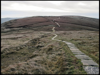
The Great Ridge and Cave Dale
Yesterday was windy, today there was no wind, but plenty of cloud
and mist.
Leaving Karen at home were she was planning a lazy day, I parked in the layby next to the gate to the path leading past Windy Knoll towards Rowter Farm. There was some sort of running event is progress with runners trotting along the muddy path from Rowter Farm and then up towards Mam Nick.
I changed into my walking boots and also followed the same route heading for Mam Nick, but I went through the gate to the steps leading up to the top of Mam Tor while the runners followed the road through the Nick.
I was soon surrounded by mist as I walked up the steps as I headed towards the trig point in Mam Tor's summit. Passing the trig point I followed the path along the ridge as it descended the continuation of the ridge in the light drizzle and mist.
I was passed by other runners and also mountain bikers (the ridge top path along this section of the ridge is classified as a bridleway) on the rather narrow stone-surface path until I arrived at Hollins Cross where another path rises from Edale to cross the ridge and drop down to Castleton. This was the route taken by the inhabitants of Edale in the distant past to take the dead over to Castleton as Edale had no church at the time.
I sat on a grassy step by the gate in the fence at Hollins Cross to have some tea from my flask. Some walkers nearby came over and asked “is this the way the 'Circular Route' goes”. I explained there was no actual named rout but there were plenty of footpaths if they wanted to follow a circular route. It seemed they had parked near Odin Mine and were making their way along the ridge planning to somehow get back to their starting point. I pointed out the directions to Back Tor and Mam Tor and they seemed happy with that.
I finished my tea and then dropped down from the ridge and out of the mist heading for Castleton. This time I met a couple as they were coming up and the bloke asked “had I turned around to come back down as I'd had enough?”. I answered that no, I hadn't come up this way so I wasn't turning around!
Anyway. I reached the lane leading into Castleton village and walked to the village square and sat on the bench circling a tree by the war memorial and had a flapjack and more tea from my flask.
Having finished my lunch, I left via Cave Dale and eventually reached the track passing Rowter Farm and the across the road to the path passing Windy Knoll where a paraglider pilot was packing away his paraglider after landing near the path having flown from Rushup Edge above.
The car was the next stop.
 |
| Misty summit of Mam Tor |
 |
| Mountain Biker and runners disappearing into the mist |
 |
| Peveril Castle overlooking Cave Dale |
 |
| Looking down from the top of Cave Dale |
 |
| Paraglider landing |
Saturday, 16 November 2013
Kinder Scout
Up via Grindslow Knoll, down via path east of Ringing Roger. Very
windy.
Karen was visiting friends on the Isle of Man and I had another trip to Kinder Scout. The weather forecast was for a dry but cloudy day with a westerly wind around 20 to 30 miles and hour so I decide to walk up vis Grindslow Knoll and then descend via Ringing Roger so that I would have the wind behind me most of the time.
After leaving the car in the main Edale car park I made my way into the village and then followed the start of the Pennine Way before turning off a short while later to start the ascent to Grindslow Knoll.
Near the top I saw a group of 3 oriental people, a young man and two girls who had been in front of me stop and the turn around. They seemed very cold even though they were wrapped up well – it was around 8 degrees with a bit of wind. Then near the higher section with the rough steps a couple were descending and the man told me it was very windy at the summit and pointed to the clouds rapidly being blown down the Gindsbrook valley.
Well, he was right! When I reached the summit of Grindslow Knoll it was so windy it was difficult to stand still. I had been wearing a Paramo Summit Hoodie fleece jacket only so far but with the wind I decided to add a windproof jacket on top so I ducked down in the shelter of one of the small craggy bouldrs and got a Paramo Vista jacket on overt the top.
Instead of walking the path skirting the top of Grindsbrook Clough, I followed the slabbed path leading towards Crowden Clough and the turned right along the slabbed path towards the top of Grindsbrook Clough. Once off the summit, it wasn't nearly as windy, which is what I expected.
So I followed along the edge path as it wended around the northern branch of the Grindsbrook river and then along the northern side of Grindsbrook Clough.
When I got part way between Upper Tor and Nether Tor, I decided to follow a small valley heading northwards and then make my way across the plateau towards Blackden Edge overlooking the Snake Pass.
I made my way along the path on this side of the plateau which has no slabs and hence was more muddy and boggy, but much quieter of course as you get less people around once you get further from Edale.
I could see the trig point at the 590 metre spot height in the distance with a couple of boulder outcrops in between and I then made my way towards the boulders having to make slight detours to get around some rather deep cloughs (the deep channels worn by water in the peat). I lost sight of the trig point but after checking the map I could see there was an indefinite path leading towards Madwoman's Stones, so I just headed that way for a while.
Soon I saw a mountain hare dart off at a gallop as I approached too close. The hare was not yet in its white winter coat and very quickly disappeared.
In the distance I could see Win Hill so I tramped through the rough heather to the right of the hill intending to eventually reach the vicinity of Ringing Roger.
As I approached the southern edge of the plateau, more of the Great Ridge separating the Edale and Hope Valleys grew in view.
I arrived at on of the narrow paths making its way parallel to the edge and after following this for a while, left it for the path which descends from the edge below and to the east of Ringing Roger.
I passed a couple of blokes coming the other way towards The Nab, one with a huge rucksack and the other struggling with a mountain bike. I pointed out that he wasn't really allowed to cycle up a public footpath but anyway I left him to his struggle. He didn't seem to be enjoying himself!
Soon I was back at Grindsbrook Booth and on the way back tot he car park I had a snack at the Penny Pot café next to the train station.


Saturday, 9 November 2013
Kinder Scout
Karen had luckily managed to get a trip into the Speedwell Cavern
system with a group we know after one person dropped out of the trip
– so there was no room for me! Because of that, we were up early
for a Saturday and I set off to park at the layby at Upper Booth
arriving just after 0900. Not surprising, mine was the first car of
the day.
After getting my boots on I walked along the road passing Upper Booth Farm with the coolest weather for a long while and made my way towards Jacobs Ladder to gain the Kinder plateau near Edale Rocks.
It had been a bit frosty fist thing and some of the large slabs making up the path were slippery so I was careful as I walked on them.
After passing the Pagoda (a large gritstone formation near the plateau edge) I made my way through the natural sculpture park known as The Woolpacks (or Whipsnade). The weather was cold with a sharp wind but with excellent visibility and long sunny periods with occasional cloudy sections.
After passing the tops of the brooks at Crowden Clough and Grindsbrook Clough, I decided to follow the northern branch of Grind Brook for a few hundred metres to reach the shelter of Four Jacks Cabin. This is a small 2 metre by 2 metre drystone-wall structure with only parts of the walls remaining. However, it is next to the brook and has a number of flat stone slabs inside to sit while sheltering from any wind.
Here I boiled up some of the peat-stained water from the brook to make a brew and eat my sandwich for lunch.
Afterwards, I followed back along the brook the way I had come earlier and then continued on the southern edge path above Grindsbrook Clough heading in the direction of Ringing Roger.
I dropped down the path which follows parallel to and below the rocky ridge of Ringing Roger and made my way to Grindsbrook Booth.
From there, I followed the route of the Pennine Way back to Upper Booth Farm and then to my starting point.


Sunday, 3 November 2013
Water Icicle Close Cavern
It was my turn to accompany some cavers in the North-west passage
extensions today. We had arranged to meet in the Old Smithy café in
Monyash and as Karen and Keith were planning to spend some time
tidying up the club tackle store, they also had breakfast in the
café.
When we arrived, Tom and Owen were already in the café: there were to be only the two of them today.
After breakfast, I left Karen and Keith in the café and set off in my car for Derby Lane followed by Tom and Owen in their van. As it had been very wet, we didn't drive to the end of the green lane but stopped on a wide section where it was still rocky as otherwise the wet soil and mud would have made it very difficult to get much further.
We got changed and walked to the end of the lane and climbed over the horse jump and then across the field to the shaft top.
Tom rigged the rope they had brought and I abseiled down first. They had a 35 metre rope and it was just the right length.
Once we had finished our look at the new stuff, I prusiked up first to open the shaft lid and found that it was just beginning to rain. The consolation was there was a whole rainbow stretched across the sky from the other side of Derby Lane to the upper part of Lathkill Dale.
We walked back to the cars in the rain and had a very unpleasant time getting changed and after saying good-bye to the others, I headed for the Orpheus hit to find Karen and Keith just finishing off their re-organisation of the tackle store while Boyd and Waggy were teaching basic SRT to a couple of prospective members on the gable end of the cottage.
Saturday, 2 November 2013
DCA Council Meeting and Bonfire Night
To begin the day, Karen and I attended the DCA Council meeting in
Monyash Village Hall. Luckily it was quite a wet morning so it didn't
seem to bad being indoors in a meeting!
Afterwards we had a short visit to Bakewell to get a few things.
Then in the evening, despite gale force winds, the annual Orpheus Caving Club bonfire and fireworks part went ahead as usual. Luckily there was no rain, even if it was very windy.
Afterwards we had a short visit to Bakewell to get a few things.
Then in the evening, despite gale force winds, the annual Orpheus Caving Club bonfire and fireworks part went ahead as usual. Luckily there was no rain, even if it was very windy.
Subscribe to:
Posts (Atom)