As Karen woke up with a headache and sore throat she stayed in bed while I had breakfast and collected my caving gear.
We had intended a trip to P8 so that I could get my oversuit clean but even though Karen was not now going caving, I drover to the Orpheus cottage anyway to see what was happening,
Mick Hogg was there on his first visit for many moths still recovering from a bout of appendicitis and wanted to do something involving SRT which wasn't too or strenuous so I suggested Knotlow Cavern.
After sitting around drinking tea to see if the light rain would let up, we eventually headed for Monyash at nearly noon and luckily had the Triangle to ourselves as others had told us that they had been there last week or the week before and almost had difficulty finding a place to park as it was so busy!
We dropped down the Climbing Shaft and the second pitch into Pearl Chamber. Continuing on into the cave to the Waterfall Pitch, Mick decided he would wait at the top while I rigged the traverse and dropped down the pitch.
There was quite a lot of water in the waterfall and as I hadn't rigged the lower deviation, I swung in the water a bit so managed to wash my oversuit after all!
I stopped on the rope when I reached the waterfall and then changed over to prusiking and returned to the top of the pitch.
After de-rigging we continued out and I waited by the Climbing Shaft on the surface with the rope from the Waterfall Pitch ready to drop down to Mick to provide some assistance if he needed it but he didn't in the end.
After a quick trip to the cafe in Monyash, we returned to the hut.
Sunday, 27 February 2011
Sunday, 20 February 2011
Lathkill Dale from Monyash
All of yesterday's snow had melted at home but there was still a thin layer of snow on the higher ground as we drove along the Ashbourne to Buxton road (A515) on our way to Monyash.
Leaving the car at the village green, we walked along the Bakewell road until we reached the beginning of Lathkill Dale.
Following the broad beginning of the dale, we then branched off on a small footpath which led gradually upwards on the left-hand side.
This brought us to the old limestone quarry of Ricklow Quarry.
We continued along the side of the dale with spectacular views along the broad dale ahead and behind.
At on point we were directly opposite the small shaft which leads into the Top Entrance of Lathkill Head Cave and we saw two cavers wandering around in the field obviously looking for the shaft.
We were able to shout across to them to direct them to the shaft, which they reached in a couple of minutes.
Continuing along the dale side, we stopped for a few minutes to have a hot drink and snack and after passing the obvious resurgence of the large opening of Lathkill Head Cave far below we were now accompanied by the sound of running water rushing along the dale bottom as it reached the surface after flowing out of the cave and also being joined by several springs spouting out of the valley side.
Opposite Cales Dale we followed slippery steps made from local limestone and a narrow path which led down gradually to the dale bottom directly opposite a small footbridge.
Crossing the footbridge and passing the other nearby resurgence at Cales Dale Cave, we followed the path along one side of the dale which had a short section following a small rocky crag and slippery steps leading past what appeared to be a small atrial adit to arrive at One Ash Grange farm where the farmhouse had a collection of Snowdrops blooming in the garden and a row of interesting old stone pigsties.
Leaving the farmyard and cattle in their barn eating hay, we crossed some fields until we eventually arrived at a walled footpath which widened to a vehicle track. After following this for a while, we crossed a wall on the right using a style and then crossed several fields leading at right-angles to Fern Dale until we crossed a final stile into the grassy churchyard back at Monyash.

Monyash Chucrh

View into Lathkill Dale

View into Lathkill Dale

Cales Dale

Old Pigsties at One Ash Grange Farm

The Old Smith Cafe, Monyash
Friday, 18 February 2011
Tideswell Dale, Millers Dale and Cresbrook Dale from Litton
After a period of no snow but a few cold periods, we awoke to find a couple of inches of sleet and snow. The forecast was for an improving day and the snow was already melting.
We left Winster, driving carefully as there was a fair bit of snow still on the roads although I had to stop near Monsal Head to let some pillock pas who insisted on driving right behind me despite the conditions.
We arrived in the village of Litton and parked on the main road near The Red Lion pub and after getting our walking boots on, Karen and I followed the road out of the village heading towards the road into Tideswell.
Here we followed a path separated from the road by a drystone wall along Tideswell Dale until we arrived at Millers Dale after walking past the lovely old mill buildings at Litton Mill, where we walked along the Permissive footpath following the bank of the River Wye.
Soon we were tramping on muddy sections and trying to avoid shallow pools formed by the slightly overflowing river after all the rain and snow.
This led to a widening of the river and the well-known limestone climbing venue of Water-cum-Jolly Dale.
Part of an old building further along the Dale, part of an old building housed a small café called D's Brew Stop where we sat in the shelter and warmth to have a snack and mug of tea. This is an unusual café in that they allow you to eat your own food! It's very small but has a seating area and as well as hot and cold drinks and flapjack, etc, it also sells maps, guidebooks and items of clothing.
After the snack we followed a road uphill until we saw a footpath leading off to the right which was sign-posted to Ravensdale. We followed this to arrive at Cressbrook Dale. We followed the dale with some muddy sections and also parts where tree branches meant having to duck low in order to prevent being caught by the branches getting tangled with our rucksacks.
As we approached the main road (A 623) at Wardlow Mires, we crossed over to the opposite side of the dale and then along a footpath on the upper side which crossed some fields until we arrived at the lane we had driven along earlier on our way to Litton.
All that remained was to walk the last few hundred metres to arrive back where we had started.
Sunday, 13 February 2011
Kinder Scout
Karen, Keith and Pete planned a trip to Cascade Cavern, which is behind the Public Toilets at the top of Lathkill Dale, to see what it was like. The description in the new “Caves of the Peak District” didn't sound very promising, plus it's length was given as only 125 feet. I decided to go for a walk on Kinder instead despite the weather forecast of wind and rain.
I parked up at the large Public car park at Edale and headed off in the light drizzle towards the old start of the Pennine Way via Grindsbrook. This used to be the “official” route of the start of the Pennine Way with the route via Jacob's Ladder being an alternative before it was changed to the Jacob's Ladder route.
It was a bit wet with some wind as I walked along the broad, eroded path along the Grindsbrook Valley. The top of the Kinder plateau was enveloped in cloud and mist with the mist and cloud making the valley very atmospheric.
As I reached a rocky section where the path dwindled, there were the obvious signs of a large strip of soil and rocks having been washed down by heavy rain in the near past.
I continued scrambling up and over the boulders a I made my way up to the top of the valley and arrived at the path running along the plateau's edge.
Now the rain was a bit heavier, but the wind was much, much stronger.
I followed the path along the edge being blown around by the strong gust wind and after a while got my walking poles out to help in walking with the strong wind blowing from one side.
When I reached the path which drops back down towards Edale running below Ringing Roger, I followed this downwards taking care on the muddy and wet section at the top which is steep and rough.
Soon I was back down below cloud level with views down into Edale and also across to my ascent route with the broad well-worn path clearly visible in the distance.
Once back near the bottom of the valley, the wind was very light but still the rain continued.
Saturday, 12 February 2011
Water Icicle Close Cavern
A return to Water Icicle Close Cavern to help Keith and Pete transport scaffolding for the dig.
After having breakfast as usual at The Old Smith café in Monyash we headed towards the cave. Unfortunately it had rained quite a lot overnight so Pete wasn't able to get his car to the end of Derby Lane. He had brought about 14 scaffold poles and dropped them at the side of Derby Lane as far as he could get his car along it before parking up in a better location.
We first got into caving gear then carried these poles to the end of Derby Lane. Luckily I was able to carry three heave bags of scaffold clips in my car so at least it was only the poles to carry.
We then moved poles and clips to the shaft entrance just in time for a party of two to exit after a trip in the cave.
Keith abseiled in first and the poles and clips were then moved to the bottom of the shaft. Once all of us were also below ground, we began moving the poles and clips to the end of North-West Passage.
There were also 30 or so short sections of scaffold pole near the end of North-West Passage remaining from the original dig. Together with the longer poles we had just brought, Karen handed the poles to me as I stood at the foot of the ladder up to the breakthrough site, I then handed them to Keith who had clipped himself to the ladder with a sling part way up, and he handed them to Pete, who was at the top by the gate.
Next we all climbed up the ladder and after Keith and I had pulled up the three bags of scaffold clips then we formed a “chain-gang” through the scaffolded section of the old dig and passed the poles through to Pete at the bottom. Then we got the clips down to Pete.
Then the poles were moved through to the small chamber at the bottom of the scaffolded section and then through into the start of the larger new section. From here we finally only had to get the poles to Three-way Aven where they will be stored until they are used in shoring up the boulders and loose stone in Cherty-Two Choke.
After the hard work was finished, a return to the café in Monyash for welcome pints of tea and snacks was the next action.
Sunday, 6 February 2011
A Walk from Hayfield to New Mills
We had been planning to be in North Wales staying at the Oread Mountaineering Club hut at Rhyd Ddu but the weather forecast was so dire (very wet and very windy with gusts up to 100 mph on the tops!), we decided to stay at home in Derbyshire.
Yesterday was just very windy at rained all day even at home so it was an opportunity to stay indoors and get those things done which had been waiting for ages.
Today was supposed to be a bit less windy but drier in the afternoon after a wet night and early morning so we decided to repeat a walk which Karen had done with the mid-week walking group.
We drove to the village of Hayfield and parked in the car park from where we followed the old railway route converted to a cycle, horse-riding and walking route known as the Sett Valley Trail. The Trail is 2.5 miles long and links Hayfield with the town of New Mills.
At New Mills we walked along a path in The Torrs a gorge in the town where the rivers Sett and Goyt join. There are many old mills sited here which made use of the abundant water power and an interesting Heritage Centre. We had a break in the Heritage Centre to have a cup of tea and chocolate muffins and had a look at the various items exhibited there including a model of New Mills and The Torrs showing the various mills.
Continuing onwards after the short break the path arrived at a section where there was no river bank and a raised walkway had been built along a high wall at the side of the river. There were several old ruins of mill buildings and a modern hydro-electric scheme based on the Archimedes Screw principle next to the river. This wasn't running as the river was running very high after all the rain.
We reached a public footpath following a grassy track which was quite wet after all the rain and them followed the route across several water-logged fields.
Soon we reach high ground with views down to New Mills and Hayfield and luckily although a bit boggy in parts, it wasn't to bad under foot.
Unfortunately we could see rain moving in in the distance. Up to now it had been overcast and blustery but dry and very mild for February with temperatures at 10 degrees centigrade. Soon the rain caught us up and luckily wasn't very heavy and also as the wind was blowing from behind, the rain was also coming from behind.
We reached a small TV transmitter with a drystone wall nearby and I made use of the shelter provided by the wall to don waterproof overtrousers.
As we dropped past the transmitter and were in the lee of the hill, the wind was making the most amazing noise as it tore past the transmitter.
There remained only a short downhill stretch which brought us back to Hayfield and the car park.

Sett Valley Trail
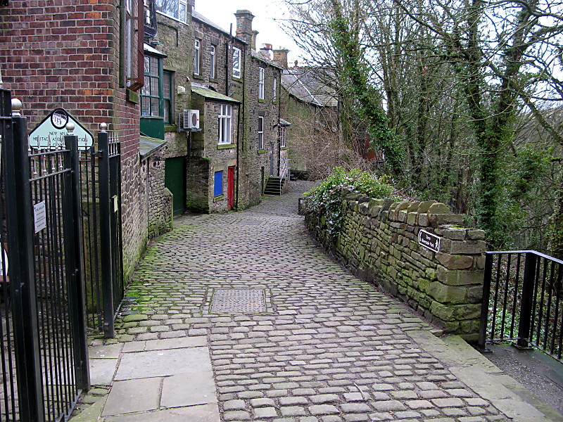
Cobbled lane outside Heritage Centre in New Mills

Old riverside mill buildings

One of the exhibits in the Heritage Centre

Model of the many mills in old New Mills

The raised walkway beside the river

The llamas and their garden shed
Subscribe to:
Comments (Atom)